
GNSS-7000 Signal Simulator
GNSS-7000 Signal Simulator
GNSS-7000 Signal Simulator
Four-System Simulator: GPS/GLONASS/BDS/Galileo
Product Appearance
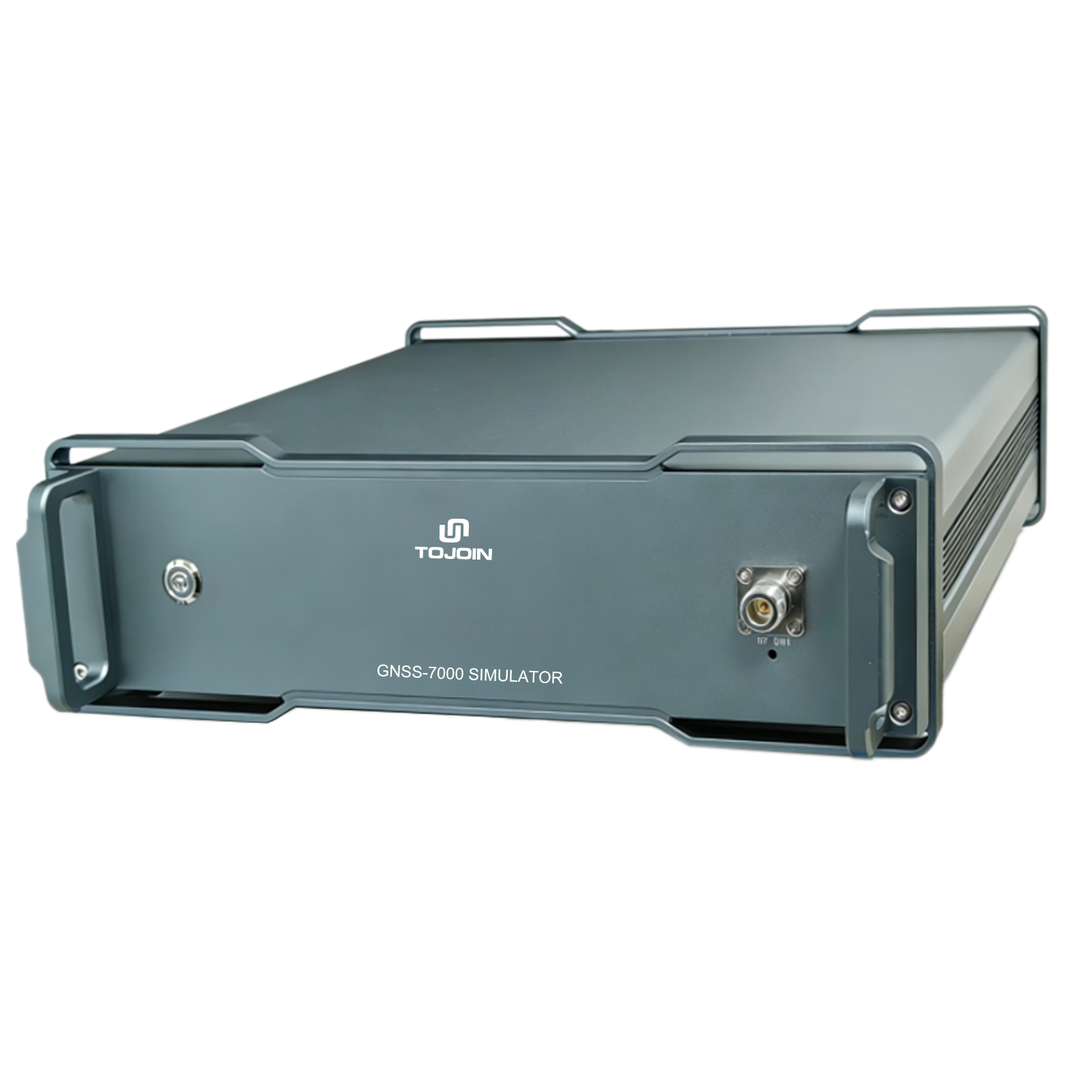
Product Overview
The GNSS-7000 Navigation Satellite Signal Simulator is a cost-effective, four-system satellite positioning, navigation, and timing (PNT) signal simulation system.
It supports full-constellation, full-frequency-band GNSS signal simulation. By configuring constellation, signal, and carrier models through the SimPNT software, it can generate high-precision, high-dynamic-range RF signals. It also features robust on-site upgrade capabilities and flexible configurability, allowing users to configure GNSS constellation and frequency signals for output according to their specific requirements.
It supports real-time ephemeris and external ephemeris parameter input, as well as the output of various trajectories of different durations. It meets the testing requirements for a wide range of satellite positioning and navigation receiver scenarios, including R&D and production.
Big Deal
Supports the four major navigation systems: BDS, GPS, Galileo, and GLONASS;
Supports complete L1, L5, and L2/L6 signals;
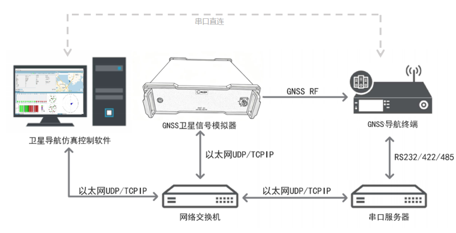
Includes the SimPNT software client for flexible configuration of parameters such as location, trajectory, and satellite settings;
Used for routine testing in GNSS R&D;
Navigation anti-jamming and anti-spoofing testing;
Sensitivity testing & CN0 testing;
Supports 24/7 long-term signal testing;
Supports remote control via LAN for flexible deployment.
Industry Applications
Widely used in all stages of the research, development, production, and testing of user devices for positioning and navigation. It can perform positioning tests, velocity tests, delay tests, and related accuracy tests.
It is suitable for the research, development, and testing of products that rely on satellite navigation and positioning functions, such as autonomous driving systems, navigation and positioning devices, and geofencing devices. It can significantly improve efficiency, eliminate the need for frequent on-site field testing, and greatly accelerate the speed of product development, testing, and deployment.
Technical Parameter
| Parameters | Specifications |
| Signal Frequencies | Beidou: B1I, B1C, B2I, B2a, B2b, B3I |
| GPS: L1 C/A, L2C, L5 | |
| GLONASS: G1, G2 | |
| Galileo: E1, E5a, E5b | |
| QZSS: L1, L5 | |
| Signal Dynamics | Simulated Altitude ≥ 8,000 km |
| Relative Velocity ≥ 10,000 m/s | |
| Signal Accuracy | Pseudo-range Accuracy ≤ 0.05 m |
| Pseudo-range Rate Accuracy ≤ 0.01 m/s | |
| Signal Quality | Harmonic Suppression ≤ -40 dBc |
| Spurious Suppression ≤ 50 dBc | |
| Frequency Stability ≤ 5×10-11 | |
| Default Signal Level | -130 dBm * |
| Gain Control Range | 0–80 dB |
| Level Adjustment Increment | 0.1 dBm |
| Environmental Specifications | Operating Temperature: 0°C to +50°C |
| Relative Humidity: ≤90% (at 40°C) | |
| Storage Temperature: -20°C to +80°C | |
| Power Supply Specifications | DC 19.5 V / 11.8 A |
| Dimensions | 365×450×110 mm |
| Weight | < 10 kg |
| Number of Satellite Channels | 128 |
| Number of Multipath Channels | No fewer than 6 per frequency point |
| RF Signal Carrier Frequency Deviation | ≤ ±50 Hz |
| Power Range | -140 to -50 dBm |
| Power Resolution | ≤ 1 dB |
| Power Deviation | ≤ 1 dB |
| Velocity Dynamic Range | ≥ 10,000 m/s |
| Acceleration Dynamic Range | ≥ 1,000 m/s² |
| Acceleration Dynamic Range | ≥1000 m/s³ |
| Pseudo-range Resolution and Pseudo-range Error | ≤0.05 m |
| Pseudo-range Rate Resolution and Pseudo-range Rate Error | ≤0.03 m |
| Harmonic Suppression | ≤-40 dBc |
| Non-harmonic Suppression | ≤-50 dBc |
| Phase Noise | ≤-75 dBc/Hz @ 100 Hz |
| ≤-80 dBc/Hz @ 1 kHz | |
| ≤-85 dBc/Hz @ 10 kHz | |
| ≤-90 dBc/Hz @ 100 kHz | |
| Relative frequency deviation | ≤ 5×10⁻⁸ |
| Frequency stability over 1 s | ≤ 0.5×10⁻⁹@1s |
Remote Control Software for Navigation Satellite Signal Simulators
Features
Flexible deployment of client applications
Map mode, intuitive and easy to use
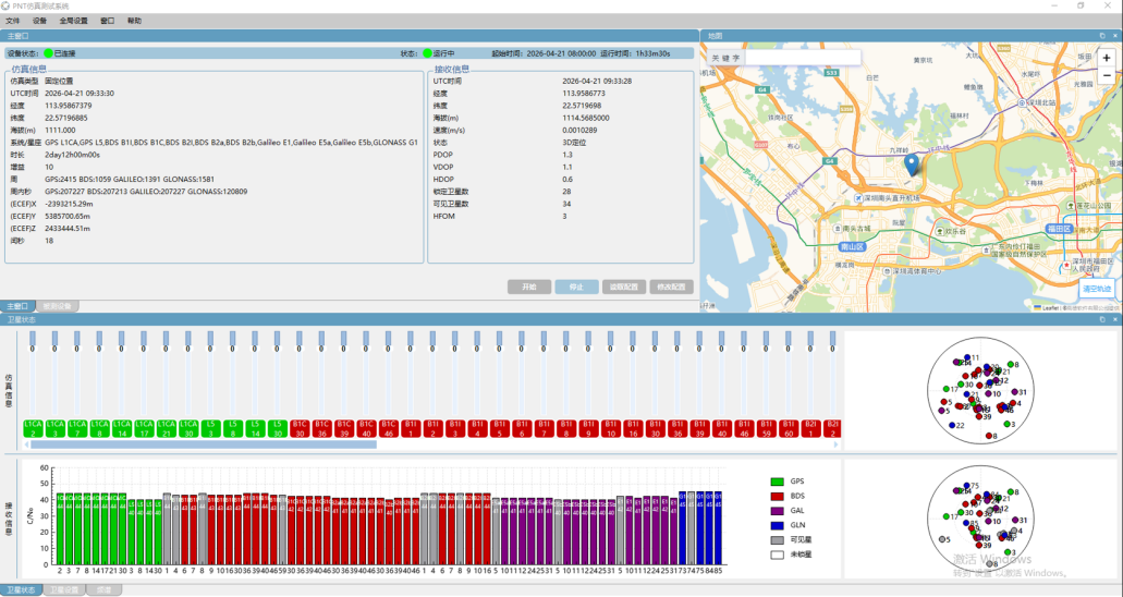
Real-time synchronized display of simulation and reception
Real-time trajectory simulation/position simulation
Functional Application
Supports fixed positions, circular trajectories, linear trajectories, variable-speed trajectories, and custom imported trajectories
Supports speed, acceleration, and double-acceleration settings
Supports leap second testing and 1,000-cycle testing
Supports receiver data acquisition; supports local or remote serial port reading
Simultaneously displays simulation data and received data
Simultaneously displays simulated trajectories and received trajectories
Supports online and offline maps
Supports map point selection and trajectory preview functions for intuitive viewing of latitude/longitude positions and motion trajectories
Supports range settings for simulated satellites; allows selection of satellites within specified elevation and azimuth angles
Supports masking satellite signal frequencies and specific satellite IDs during testing
Supports real-time adjustment of signal strength and CN0 values for individual satellites during testing
Real-time status display function, showing a zenith view of currently visible satellites and signal bar charts
Displays information such as satellite type, quantity, ID, and elevation angle
Supports test logs and secondary development
Function Flow Demonstration Diagram
SimPNT Simulation Test System
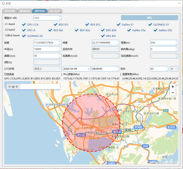 | 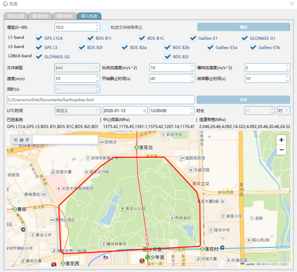 |
| Legend: Circular Trajectory Settings | Legend: Custom Trajectory Settings |
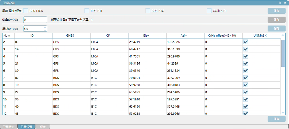
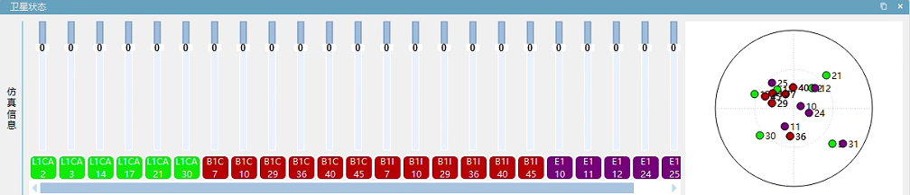
Legend: Satellite Frequencies, Single-Satellite Control, and CN0 Settings
*The information in this document is intended to assist users in product selection. Users are advised to conduct tests to determine whether the product meets the requirements of the corresponding application scenarios. Product specifications and descriptions herein are subject to change without prior notice.